Sand Dunes, a natural wonder in Parangtritis, Yogyakarta
30/07/2022 Views : 416
I Putu Yogi Darmendra
According
to the Indonesian Dictionary, a dune is a small sand hill on the beach.
Meanwhile, according to Shuckin, sand dunes are accumulations of sand formed by
wind, both in coastal and desert areas. So, a sand dune is an accumulation of
sand that is lifted by wind power (eolin) to an area on land and form a certain
appearance. The process of moving material in the form of sand and fine grains
occurs over a long period of time and occurs continuously. This process is
known as deflation. Parangtritis Sand Dunes is a unique phenomenon, because the
process involves the landscape from upstream to downstream. Parangtritis Sand
Dunes are formed from sand material from the activities of Mount Merapi in the
upstream area, which is carried by rivers that originate at Mount Merapi, which
then settles in the estuary and is later carried by currents and waves to the
beach (Sungkowo et al, 2014).
The
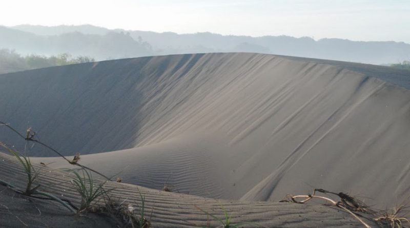
main uniqueness of the sand dunes in Parangtritis is the type of sand dune
formation. On the sand dunes in Parangtritis, there are barchan or crescent
type sand dunes. This type of sand dune is rare because it only forms in a few
places, such as in the Philippines and Vietnam (Putra, 2016). The shape of this
barchan-type sand dune is characterized by the appearance of 2 horns, and
closely resembles the shape of a crescent moon. The height of this sand dune
can reach 5 to 15 meters. The barchan-type dune is located in a relatively flat
area with strong and stable wind speeds. This type of sand dune is very easy to
move, which really depends on the size of the dune. The smaller the size of the
pile, the faster it will move.

Figure
1. Barchan-type dune in Parangtritis
Source:
pgsp.big.go.id
The
sand dunes formed in Parangtritis are not only admired for their beauty, but
also for their ecological functions. Sand dunes have the ability to prevent
coastal disasters. Some coastal disasters that can be prevented by the presence
of sand dunes include:
1.
Tectonic earthquake vibration damper; The sand dune texture has the ability to
absorb earthquakes, as happened in the 2006 Yogyakarta earthquake, where
buildings in the sand dune area only suffered moderate to light damage.
2.
Damping tsunami waves; The morphological type of Sand Dunes area, where the
shape stretches for two kilometers with a height of up to 15 meters serves to
dampen the impact of the Tsunami waves
3.
Recharge Areas; Through the process of infiltration and percolation in the sand
dune, the rainwater that is accommodated in the sand dune will become fresh
groundwater. With this advantage, the availability of fresh groundwater on the
coast will be maintained and prevent seawater intrusion
4.
Prevents abrasion and erosion from high sand dunes
To
support the ecological function of the sand dunes, the sand dunes need to be
protected by the government by creating a legal protection. Therefore, the
Government affirms the protection of sand dunes through various legal grounds,
one of which is in Presidential Regulation no. 51 of 2016 about Coastal
Boundaries, Article 4, it is stated that one of the objectives of determining
coastal boundaries is for the preservation of ecosystem functions and all
resources in coastal areas and small islands, including sand dune ecosystems.
Under the regulation, there is also a Decree of the Head of the Geological
Agency of Yogyakarta which stipulates that the barkhan sand dunes and hot
springs in Parangtritis Village are a joint geological nature reserve area (Putra,
2016). In addition to the legal protection, on the basis of land rights, the
Parangtritis sand dune area also includes in the Greatness Area of Dalem
Gumuk Pasir Barkhan Parangtritis. This means that the entire Parangtritis sand
dune area belongs to the Sultanate of Yogyakarta (Sultan Ground) (Wulan et al,
2016)
Despite
all the regulations and rights that protect the Parangtritis Sand Dunes, the
threat of damage from Parangtritis Sand Dunes is unavoidable. The increasing
economic activity of residents around Parangtritis ultimately requires the use
of the existing space around Parangtritis which also changes the coastal area
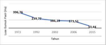
of Parangtritis (Marfai et al, 2011). Based on research on aerial photo data
in the Parangtritis Sand Dunes from 1972 to 2015, land use in the sand dunes
may increase from year to year which is marked by a decrease in the
Parangtritis sand dune area (Fakhrudin et al, 2010; Wulan et al, 2015). In
Figure 2, it can be seen that in 1972 the area of the sand dune was 396
hectares, and decreased to 239 hectares. Until 2015, the area of the sand
dune was only 33 hectares.

Figure
2. Sand Dunes area from 1972 to 2015
Source:
Fakhrudin et al,2010; Wulan et al, 2015
There
are several causes for the reduced area of the Parangtritis sand dune. One of
them is the planting of pine vegetation which was planted in 1975 (Fakhrudin et
al, 2010). This planting disrupts the wind tunnel area, which is one of the
energy forming sand dunes. Another obstacle is sandy land farming and illegal
sand mining. The development of residential areas also contributes to
inhibiting the formation of sand dunes
Various
ways have been done to save the Parangtritis sand dune, among others, by
coordinating between stakeholders in the form of restoration. This restoration
began in 2015, with the inauguration of the Gumuk Pasir Core Zone. The
restoration then continued with the relocation of residential areas around the
Gumuk Pasir Core Zone. This transfer process certainly did not go smoothly and
was rejected by some residents. Finally, after deliberation, all residents in
the Gumuk Pasir Parangtritis area wanted to be moved to the selected area. Of
course, this restoration step is a big step in an effort to save the
Parangtritis sand dunes from extinction
BIBLIOGRAPHY
Fakhruddin M,
Poniman, Aris., H. Malikusworo. 2010. Dinamika Pemanfaatan Lahan Bentang Alam
Gumuk Pasir Pantai Parangtritis, Kabupaten Bantul. Jurnal Ilmial Geomatika Vol
16 No. 2: (3-12)
Marfai,
M. A., Protomoarmojo, Nursakti Adhi., Hidayatullah, Tufik., Nirwansyah, Anang
Widhi., Gomareuzzaman, Muammar. 2011. Model Kerentanan Wilayah Pesisir
Berdasarkan Perubahan Garis Pantai dan Banjir Pasang (Studi Kasus: Wilayah
Pesisir Pekalongan). Cetakan Pertama: November 2011. RedCarpet Studio.
Yogyakarta. 80 hlm.
Peraturan
Presiden Republik Indonesia Nomor 51 Tahun 2016 Tentang Batas Sempadan Pantai
Putra,
Mega Dharma. 2016. Nilai Ekonomi Imbuhan Airtanah Dari Air Hujan Pada Kawasan
Bentang Alam Gumuk Pasir Parangtritis. UGM Yogyakarta
Shuckin, dikutip dari
buku I Gede Piata, 2009, Pengantar Ilmu Pariwisata, Andi Offset,
Yogyakarta,
hlm.203.
Sungkowo, A., E. Muryani,
dan F.A. Astuti. 2014. Penilaian Relatif Ekosistem Gumuk Pasir Sebagai Kawasan
Konservasi atau Pertambangan di Pantai Selatan. Makalah diprensentasikan pada
Seminar Nasional Kebumian – IX Fakultas Teknologi Mineral UPN Veteran
Yogyakarta, Yogyakarta 4-5 Desember 2014
Sunarto.
2014. Geomorfologi dan Kontribusinya dalam Pelestarian Pesisir Bergumuk Pasir
Aeolian dari Ancaman Bencana Agrogenik dan Urbanogenik. Pidato Pengukuhan
Jabatan Guru Besar Fakultas Geografi Universitas Gadjah Mada. Yogyakarta:
Fakultas Geografi Universitas Gadjah Mada.
Wulan,
T.R., Ambarwulan, W., Putra, A.S., Maulana, M., Maulia, N., Putra, M.D.,Wahyuningsih,
D.S., Ibrahim, F., Raharjo, T. 2016. Uji Akurasi Data UAV (Unmanned Aerial
Vehicle) di Kawasan Pantai Pelangi, Parangtritis, Kretek, Bantul. Prosiding
Seminar Nasional Kelautan 2016 Universitas Trunojoyo Madura ISBN:
978-602-19131-4-7
